Anchorage Daily News
Haines heli-ski guide in critical condition after being buried in avalanche
By DEVIN KELLY
dkelly@adn.com March 15, 2014
A guide with a Haines helicopter ski operation was in critical condition after being buried in an avalanche Saturday morning, troopers said.
Aaron Karitis, 31, was buried under seven feet of snow after traveling nearly 800 feet with a snowslide in the Kicking Horse Valley area outside of Haines, said Beth Ipsen, troopers spokeswoman. He was unconscious when he was pulled out about 30 minutes later, Ipsen said.
The incident occurred around 11 a.m., as Karitis, a guide with Southeast Alaska Backcountry Skiing Adventures, or SEABA, was finishing a conditions check downslope from his four clients, Ipsen said. A helicopter had flown the group to the 4,000 foot-elevation spot on the mountain to ski. The mountain, called Tele 5 by hele-skiers, drains into the Kicking Horse River, Ipsen said.
Karitis had decided he didn’t like the conditions on the slope, and wanted to move the group elsewhere, Ipsen said. At that point, the avalanche triggered.
“He was the only one caught up in the avalanche and buried,” Ipsen said.
Karitis was wearing a locator beacon, which is how other guides called to the scene were able to find him, Ipsen said. He was initially unresponsive when he was pulled out, and a helicopter flew him to a clinic in Haines, where he was listed in critical but stable condition, Ipsen said.
Paramedics were preparing to fly him to Providence Alaska Medical Center in Anchorage on Saturday night, Ipsen said. Karitis’ injuries were considered life-threatening.
SEABA, in a statement, pledged support to Karitis’ family and cautioned that big mountain heli-skiing had inherent risks. The company also planned to review the incident internally, the statement said.
According to his biography on the SEABA website, Karitis grew up in Bend, Ore., graduated from the University of Utah and has worked in the heli-skiing industry for 10 years.
He has been a SEABA guide since 2013 and logged nearly 300 days of heli-ski guiding in Alaska, according to the website. The site also notes international guide and avalanche certifications and an “excellent safety record.”
In March 2013, a 34-year-old SEABA guide died in a skiing accident on a mountain near Haines. That incident sparked a federal investigation into the unauthorized use of federal land by the company and led to a plea agreement in late December.
Reach Devin Kelly at dkelly@adn.com or 257-4314.
———————————————————————————————————————————————————————————————————————————————————————————————————————————————————
HAINES AVALANCHE INFORMATION CENTER
Current Conditions
Last Updated: Friday, March 14th, 2014 by Erik Stevens (Disclaimer | About This Page) Expires 11pm on March 16th, 2014 Click Here for an encyclopedia of common snow science terms from the FSNAC
| H.L. Maritime |
Transitional |
Pass |
Biggest Threats – Solar heating on south aspects – Cornices – Wind slab in other areas |
|
Subscribe to email updates:
Email Address
|
See below for details.
<!—->
| Anonymous User Poll |
| Which level of formal avalanche education have you completed?None Short Awareness Course Level 1 Level 2 Level 3/AvPro/Equiv. How many years of backcountry snowsports experience do you have? 0 to 12345678910+years |
|
| This Season: November |
| 1 |
2 |
3 |
4 |
5 |
6 |
7 |
| 8 |
9 |
10 |
11 |
12 |
13 |
14 |
| 15 |
16 |
17 |
18 |
19 |
20 |
21 |
| 22 |
23 |
24 |
25 |
26 |
27 |
28 |
| 29 |
30 |
|
|
|
|
|
|
| December |
|
|
| January |
|
|
| February |
|
|
| March |
|
|
| January |
| 1 |
2 |
3 |
4 |
5 |
6 |
7 |
| 8 |
9 |
10 |
11 |
12 |
13 |
14 |
| 15 |
16 |
17 |
18 |
19 |
20 |
21 |
| 22 |
23 |
24 |
25 |
26 |
27 |
28 |
| 29 |
30 |
31 |
|
|
|
|
|
Recent Weather Summary (Chart):
An unusually warm airmass moved in from Jan. 25th – 28th, with alpine temperatures hovering around 45 F, even at mountaintop levels. It was not raining during this time, but a massive wet slide cycle ensued. Very cold and dry weather returned through Feb. 14th, creating a solid ice crust.
Feb. 13th-15th brought 18-30″ of new snow to the mountains in three distinct storm layers (some upside-down). Winds blew from the south at times, and north at other times.
Cold and clear weather with north winds returned for the rest of February and into March.
March 8th-9th brought 3 feet of new low-density snow, turning warm and heavy at the end. Winds started out northerly, and then turned southerly.
South winds on March 9th-13th raised snow levels to around 1500ft. Around a foot of wet snow likely fell above that level, with rain below.
One more weak weather front on Friday will bring a few more inches snow above 1000ft, with steady temperatures.
This weekend is looking to be rather nice, as the next storm just misses us to the south. Clouds will begin to clear Saturday, and Sunday should be mostly sunny. North winds will pick up some, but temperatures will remain near freezing. Another weather front will move in Sunday night-Monday.
High-Latitude Maritime Zones: Slopes near Haines
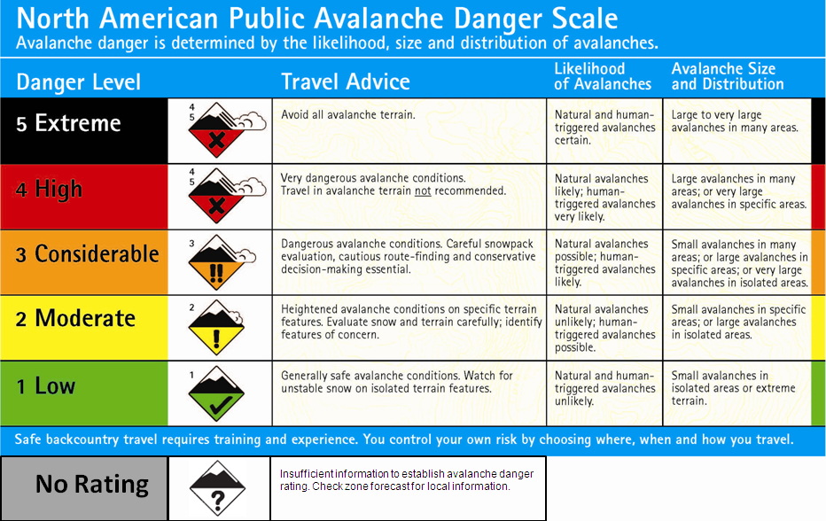
Danger: CONSIDERABLE See ScaleThere are two main concerns Friday-Sunday.
The first will be the potential for strong sunshine if/when the clouds clear up. Temperatures are expected to be a little below freezing, but the sun is getting intense on south aspects. Be on the lookout for strong solar warming, which quickly weakens wind slabs and cornices. If the sun comes out, the danger will rise to CONSIDERABLE with pockets of HIGH on south aspects: natural and human-triggered avalanches likely. Elsewhere the danger will be MODERATE: heightened avalanche conditions, especially on steep and windloaded terrain features.
Also, stay far back from cornices. This is a prime time of year for them to fall.
Besides the sunshine, the second main concern will be lingering storm snow weaknesses beneath the wind slabs that built up this week. The big storm last weekend dropped around a meter of low-density snow with a very weak storm interface in the middle, then it warmed up and we had four days of light precipitation with snow levels around 1000ft. This created a wet and heavy storm layer over the light and weak previous storm layer. South winds blew the new snow around above treeline, creating fresh wind slabs on north aspects below ridgelines, and on crossloaded east and west aspects. On steep slopes these lingering slabs may still respond to human triggering.
There is concern that avalanches may step down to a lingering weakness a meter or more deep — a buried surface hoar layer from 1-2 weeks ago. Keep this in mind, as the consequences of a slide this deep are extreme.
Be cautious out there this weekend. The new snow is not fully bonded yet, and the potential for deep slides exists. It will be very important to minimize your risk exposure this weekend. Cross/ski slopes one at a time from/to islands of safety. Remember that some treed areas that feel safe may not in fact be safe if a large avalanche occurs. Think about the potential for slabs to propagate wider than expected, and have a plan for what to do if you enter avalanche terrain. Always wear a beacon, shovel, and probe, and know how to use them.
Transitional Zones: Mountain areas seaward of interior passes
Danger: CONSIDERABLE See Scale
———————————————————————————————————————————————————————————————————————————————————————————————————————————————————

TRANSWORLD SNOWBOARDING
Photos and words: Erin Hogue
The coastal mountain region of British Columbia is experiencing a high-consequence snowpack this winter, resulting in larger more destructive avalanches with fewer warning signs. Avalanches are being triggered from up to 500 meters away, terrain that doesn’t usually experience activity is sliding, highway closures are constant and there are more burials than there have been in years. A deep weak layer coined “The Drought Layer’ has been blamed for the escalated activity.
The Drought Layer was caused by the serious lack of precipitation at the beginning of season resulting in the formation of weak layers near the ground. Over a month with only traces of snow, temperatures ranging from minus 25 Celsius to T-shirt spring conditions, wind-crusts, sun-crusts, surface hoar and faceting created a layer of weak, sugary snow. In a relatively short amount of time this weak layer was covered by up to two meters of fresh snow, at such a rate that the layers did not have the chance to properly bond together resulting in what Canadian Avalanche Centre forecasters are referring to as the “crappiest layers we’ve seen in years”.
I caught up with local Whistler pro Chris Rasman to get his perspective on the situation.
You’ve been sledding for seven years and have a lot of experience in the backcountry, reading the terrain and judging the conditions. How do the avalanche conditions this season compare to previous ones?
Well, to put it into perspective, we’ve had to be far more careful this year than any other year in the past. We’ve stayed clear of big faces, landings that are too long, and any sort of terrain traps. Not to say these are things we don’t usually avoid anyways, but we are far more timid and the guard is up big time. It seems that the bad layers that are spooking everyone this year are here to stay, and it stretches all over the Coastal mountains and the Rockies.
What signs have you seen that the snow pack this year is sketchier than in previous years?
I’m noticing a lot more natural slides and slides on faces that I have never seen go before. In January, myself and my crew were exploring some new zones near Revelstoke. We had posted up in one area and were sledding there every day for about a week straight. It warmed up a bit and created this weird hoarfrost layer on top of all the pow, and then continued to snow on top of that. It was a layer we were keeping a close eye on and was getting accumulation on top of it quickly. On the first day we decided not to go up a massive slide wiped out our single track into the zone. It was about a kilometer wide and had come all the way down to the valley, crossed a creek, and made its way up the next mountain a little, wiping out big trees as well. We saw these debris on the next day heading into the zone, and it spooked us enough to call the trip and go home. A few weeks later in Montana, we were watching everything slide with human weight on it. Short jump landings, small pillow fields, tiny little faces, even mellow pow runs in the trees were moving. We did not ride any lines or longer faces that trip.
Have you had any close calls this season?
In Montana myself and the iNi Team were hiking above a pillow line, ready to take turns riding it and all of a sudden the entire face ripped. It was a close on for sure. Other than that, so far, so good. It’s hurt a little bit to say no to some of the things, but I think we have been making the right calls.
What precautions do you take to accommodate for high avalanche danger?
To name a few, I read the reports every evening and ever morning before going out, stay away from terrain traps and any avalanche terrain when the warnings are high, take turns and watch each other closely when crossing avy terrain on our snowmobiles, and simply just be smart about decisions we make considering how we have seen this season go so far.
As a result of these conditions the CAC forecasters are advising people to wait longer than usual before moving onto larger, more aggressive terrain. Some runs might have to wait for a couple of weeks or more. Some might be out for the rest of the season. This is especially important for people in the coastal ranges who are used to waiting a few days to let things settle down, then going for it. The snowpack out there, especially the south coast, is like nothing many people have dealt with before. Don’t use your coastie tactics and expect them to work this season. Think more like the Interior or even the Rockies guys right now.


